 |
|
CITY STREETS AND
|
A: Hillside is also known as "Depot Grade" as it goes up the hill from the train depot.
Q: Where is Crescent Grade?
A: The street sign reads "Crescent Drive" and it goes from Spring Street up past St. Elizabeth's Catholic Church.
Q: Where is Ellis Grade?
A: "Ellis Grade" is the street from the Child Development Center or Harmon Park up to Prospect Street where, on the left, you'll see the Crescent Hotel. The blue house on the corner was Dr. Ellis' home. It was later known as Katy's Corner and, even later, it became the original Victorian Sampler. Sanborn's 1909 map shows Ellis Grade - but with the name Glen Avenue.
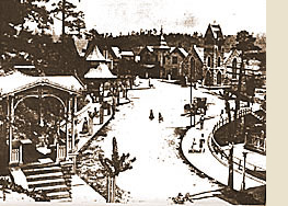
Q: What was "The Boulevard"?
A: Spring Street from Crescent Spring (where the Presbyterian Church is in the middle of the fork of Hillside and Spring) on to Ellis Grade used to be called "The Boulevard".
 Q: When were the rock retaining walls built?
A: Most of them went up in the 1880's and most sources claim that 54 miles of them exist.
Q: How do you find your way through the Historic District?
A: The best way is to ignore all the street signs since, according to the local Post Office, the Historic Loop changes names 7 times between the Family Medical Center and the Crescent Hotel alone.
Just follow the signs that say "Historic Loop (old 62B)". It will take you on about a 2 mile tour of the business district, Victorian homes, and other residential areas from HWY 62 and back. This loop was called HWY 62B until the late 1980's when the state took their signs down and turned the road over to the city. New street signs were put up by the city declaring old 62B the "Historic Loop."
Kindly provided by Susan Schaefer. All Rights Reserved. Information presented here is used with the permission of the author.